


bourg Murat le volcan

RoMo
User
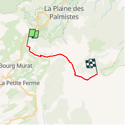

Length
15.7 km

Max alt
2427 m

Uphill gradient
887 m
Km-Effort
26 km

Min alt
1641 m

Downhill gradient
288 m
Boucle
No
Creation date :
2019-11-12 04:20:06.276
Updated on :
2019-12-03 15:30:44.816
7h50
Difficulty : Medium

FREE GPS app for hiking
 SityTrail
IGN / Geographical institutes
SityTrail Plus
The world is yours!
About
Trail Walking of 15.7 km to be discovered at Réunion, Unknown, Le Tampon. This trail is proposed by RoMo.
Description
belle randonnee
Positioning
Country:
France
Region :
Réunion
Department/Province :
Unknown
Municipality :
Le Tampon
Location:
Unknown
Start:(Dec)
Start:(UTM)
353398 ; 7657426 (40K) S.
Comments